

A DJI M210 drone, supplied by heliguy™ and equipped with a custom payload, has been described as one of the best systems on the planet for carrying out short-range gas inspections of volcanoes.
The aircraft was one of a number of drones used for groundbreaking research to explore volcanic emissions in Papua New Guinea, as part of vital work to help protect local communities and make inspections safer and more accessible.
Led by Emma Liu, of the University of Cambridge, the major expedition - funded by Deep Carbon Observatory (DCO) - was a collaboration between several international teams of scientists and local volcano observatories to investigate the strongly degassing volcanoes of Manam, and Tavurvur, in Papua New Guinea.
"The M210 is super easy to fly and could happily carry the 800g gas-sensor payload," - Dr Kieran Wood
The ABOVE (Aerial-based Observations of Volcanic Emissions) project took place in May and June and used drones and fixed-wing aircraft equipped with gas sensors, spectrometers and sampling devices to acquire near-vent measurements of carbon dioxide and other gases. The project was a collaboration involving research teams from universities in the UK, Costa Rica, Germany, New Zealand, Sweden, Italy, and USA.

Drones were a key tool in this research, changing the way that the scientists were able to sample previously inaccessible volcanic plumes and acquiring information which was limited through ground-based techniques.
"Drones are changing the way we study volcanoes and have enormous potential for monitoring volcanic hazards,” - Dr Emma Liu
Amongst the various drones involved in the research, DJI platforms were used to teach local scientists at the Rabaul Volcanological Observatory (RVO) how to integrate this technology into their regular monitoring activities and volcanic crisis response.
DJI M210 Was A Vital Tool In Volcanic Research
As the UK’s biggest DJI direct retailer in Europe, drone expert heliguy™ was able to supply the local observatory staff with the previously mentioned M210, as well as two Mavics.
The robust M210 was fitted with a gas-sensor payload - made at the University of Palermo, in Italy, and funded by DCO - and helped the team to collect some very good data sets in the densest part of the volcanic plume at Tavurvur.

In a glowing endorsement of the product, ABOVE team member Dr Kieran Wood, from the University of Bristol, said: "This system is currently the most versatile short-range drone-based volcanic gas-sensing system on the planet I have used".
“The M210 is super easy to fly and could happily carry the 800g gas-sensor payload via a custom 3D-printed attachment I made up in the University of Bristol Flight Lab.”
"Ordering from heliguy™ was super easy and the company dealt with a very last-minute problem we had," - Dr Kieran Wood
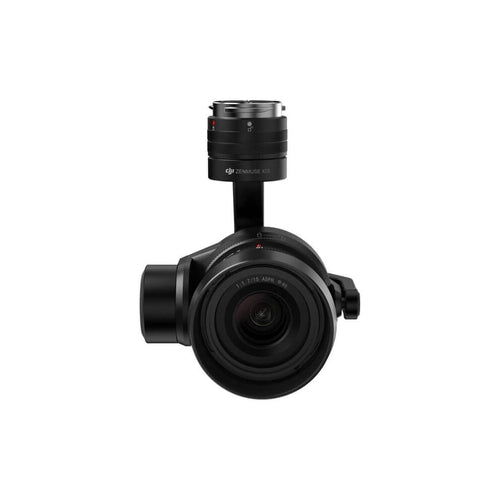
The team also integrated a DJI Zenmuse X5S with the drone, using the high-quality camera to recce the sites before the gas sensor was flown.

Back in March – prior to the expedition – Dr Wood and Dr Liu travelled to Papua New Guinea to run a drone workshop in cooperation with RVO and funded by the Global Challenges Research Fund (part of UK Research and Innovation). They used the M210 and the two Mavics to train the locals and left these drones for the RVO for its continued use in regular volcanic monitoring of Tavurvur.


Dr Wood said that the locals were impressed with how simple the DJI drones were to operate. The out-of-the-box nature of these aircraft ensured that they could be flown quickly and easily once the pre-flight checks were completed.
These drones were subsequently made available for the ABOVE team when they returned for the main expedition and the RVO staff were also able to fly a few missions themselves.

On returning to the UK, Dr Wood praised the support that heliguy™ gave the team.
He said: “Ordering from heliguy™ was super easy and the company dealt with a very last-minute problem we had with one of the batteries, by sending a replacement immediately, and even loaning another spare just in case there was another problem while we were in Papua New Guinea.”
The locals in Papua New Guinea were impressed with how easy it was to fly DJI drones.
It isn’t the first time that Dr Wood has worked with heliguy™ equipment. Earlier this year, he was part of a research group which completed the most comprehensive survey of Chernobyl’s Red Forest by using a suite of drones and fixed-wing aircraft, including a DJI M600 Pro supplied by us.
The 3D maps created from the drone flight not only provided up-to-date information on the sites with the greatest contamination but also revealed previously undetected radiation hotspots. You can read the full story by clicking here.

heliguy™, which recently won a DJI Enterprise award, has a track record of working with universities and research teams. Examples include:
- Integrating a LiDAR system with a DJI M600 Pro for the University of Newcastle. Read more here and see picture below (first image).
- Supplying the University of Newcastle with a DJI Phantom 4 RTK to help with a mapping project. Watch the video here.
- Supplying a DJI Phantom 4 Pro for the first drone count of Atlantic grey seal pups on the Farne Islands, off the Northumberland coast. Read more here and see picture below (second image).
- Integrating a drone with a Sony A7R, thermal and MAIA multi-spectral camera for the James Hutton Institute for river surveys. Read more here and see picture below (third image).
- Providing equipment and industry advice to Dr Joseph Cook, a glaciologist at the University of Sheffield, who is exploring the impact of global warming on glacier and ice-sheet dynamics in the Arctic. Read more here.


heliguy™ is also drawing up plans to work with young people to fuel their passion in robotics, programming and coding, by using the RoboMaster S1 (below, first image) and the Tello EDU (below, second image) – two educational tools which utilise DJI’s advanced technology. Read the story here.


Drones Propelling Volcano Research ‘Into The Next Decade’
Put simply, drones have become a vital and unique tool in collecting data from volcanoes.
As Dr Liu says: “Drones are changing the way we study volcanoes and have enormous potential for monitoring volcanic hazards.”

Studying the release of volcanic gases is extremely important as it can help scientists understand what is happening deep beneath the volcano. Indeed, a change in the chemistry of these gases can precede large eruptions.
However, to measure the release of carbon, researchers need instruments which can get extremely close to the vent of the volcano. And this is where drones come in.
"Many areas of the volcano are too dangerous to reach on foot, so we used drone technology to get our instruments close enough for direct measurements," - Dr Emma Liu
Thanks to these dependable machines, scientists can now sample volcanic plumes which were previously inaccessible using ground-based techniques.
This is vital in driving forward research.

“This new technology will propel deep carbon science into the next decade,” says Dr Liu.
This was clear to see during the Papua New Guinea expedition.
"From data collected from our drones, we, as volcanologists, are beginning to fill in the last remaining gaps in our knowledge of how much carbon is being released by volcanoes around the world and why,” - Dr Emma Liu
At Manam, the team used drones to obtain the volcano’s first suite of volatile data and fluxes, which will be analysed to fill a critical gap in the data set of global volcanic carbon emissions.
The scientists also targeted the isotopic composition of emitted gases to investigate the source of carbon supplying the Papua New Guinea volcanic arc.

Thanks to drones, the aerial overflights were able to confirm strong outgassing from two vent sources in the summit area.
Dr Liu said: “Manam is one of the most active volcanoes in Papua New Guinea and it is one of the most challenging to measure from the ground. Instead, we took to the skies.
“From data collected from our drones, we, as volcanologists, are beginning to fill in the last remaining gaps in our knowledge of how much carbon is being released by volcanoes around the world and why.”
In the case of Tavurvur Volcano, in Rabaul, Dr Liu continued: “The crater at Tavurvur contains many active fumaroles – cracks in the ground where hot gases escape.

“Many of these are too dangerous to reach on foot, so we used drone technology to get our instruments close enough for direct measurements.
“Our work at Rabaul is part of a larger project aiming to expand the use of drones for volcano monitoring. In time, our goal is for RVO to monitor volcanoes routinely from the air, helping their ongoing work to safeguard the people of Papua New Guinea from volcanic hazards.”

Over the next few months, the team will be collating the results and publishing new insights into the carbon dynamics of the Papua New Guinea volcanic arc.
They also hope that through this work at Papua New Guinea, methods for data collection using equipped drones can be optimised and easily adoptable, standardized methods for future field deployments can be developed.

The ABOVE team was keen to be involved in outreach at a community level in both disaster preparedness and education.
As part of the expedition, they visited the local primary school on Manam to speak to the students, show some of the techniques that are being used to explore the volcano – including drones – and to learn about ongoing challenges of building a community in the face of such volcanic hazard.
The team also met members of the Manam Volcanic Disaster Response Committee, a community-led programme to increase their own resilience.

To find out more about the drones for inspections or how heliguy™ can help you, contact us by phone or email.

Leave a comment