
- heliguy™ partners with Esri UK to provide an end-to-end workflow for the AEC industry;
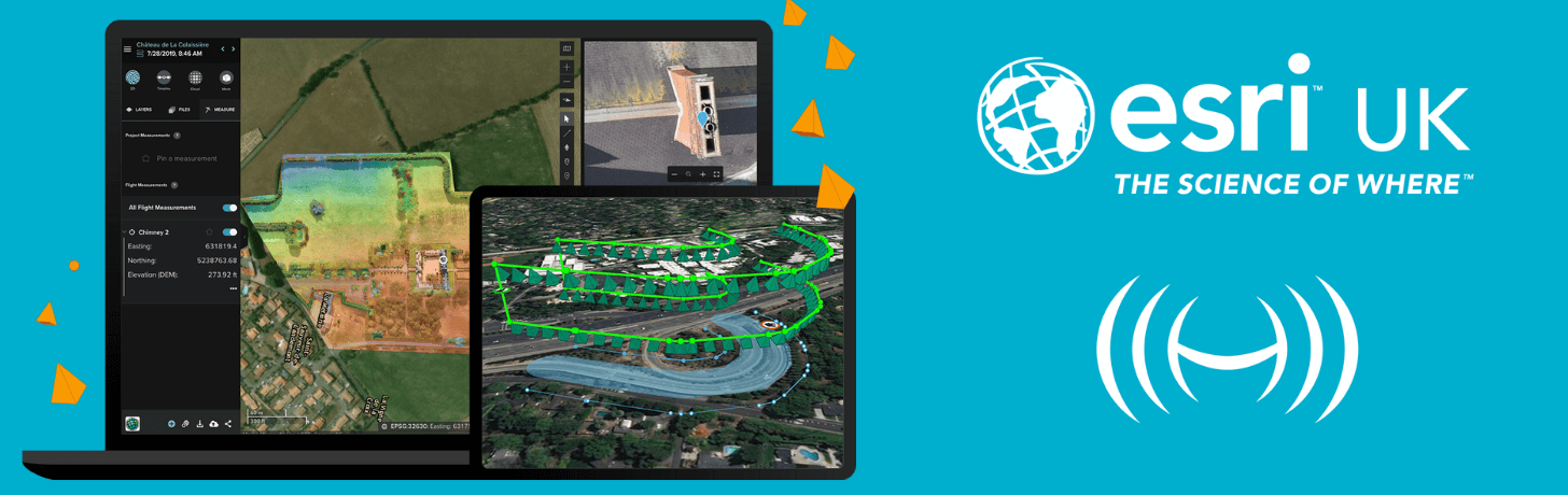
- The alliance combines heliguy™'s drone services - such as supply and training - with Esri UK's flight planning and data capture and processing software, centered on Site Scan for ArcGIS;
- The aim is to provide a comprehensive and integrated solution to enable drone programmes to scale and maximise data collection and insights;
- Sign up for heliguy™-Esri UK webinar, taking place on November 19.
Drone specialist heliguy™ has announced a new partnership with Esri UK to complete an end-to-end drone solution for the AEC industry.
The alliance will provide a comprehensive aerial surveying drone workflow.
It brings together heliguy™'s multi-faceted drone industry approach of consultancy, hardware supply, pilot training, and in-house repairs and R&D, with Esri’s existing flight planning, data capture, data processing and GIS software - centered on Site Scan for ArcGIS.

The partnership is designed to offer a compelling solution to large AEC organisations looking for integrated and scalable drone programmes.
It aims to streamline current processes, from drone management and data capture, through to better sharing of outputs across a business and integration with BIM and CAD workflows.
heliguy™’s vast experience and training capabilities, coupled with Esri’s cloud-based software, are a perfect match for the AEC industry’s new requirements.
Craig Evenden, Head of AEC & BIM at Esri UK
Current Esri drone software customers include Skanska Norway, Arcadis globally and PCL Construction in North America, while UAV specialist heliguy™ manages some of Europe’s largest drone programmes, working with Balfour Beatty, Atkins and Network Rail.

'Partnership Will Help Customers Maximise Investments'
Craig Evenden, Head of AEC & BIM at Esri UK, said: “Esri has invested heavily in creating its drone technology and this new relationship completes the picture in the UK.
"By providing a single source of hardware and software, the partnership will help customers maximise their investment in drones and GIS.

“As drone usage grows, accelerated by the Covid-19 pandemic, the AEC community is demanding more integrated programmes that can easily grow across their business.
"heliguy™’s vast experience and training capabilities, coupled with Esri’s cloud-based software, are a perfect match for the AEC industry’s new requirements.”

Through the new partnership, Esri UK and heliguy™ will work on joint projects, aiming to introduce new and more efficient workflows by bringing together customers’ GIS and Survey teams who have traditionally worked separately on drone-related projects.
Ruairi Hardman, Business Development Manager at heliguy™, said: "The AEC drone industry is still in its infancy which sees many piecemeal projects and no proper joined-up internal approach, which leads to failure.

“Internal drone programmes that can scale across a business are a fairly new phenomenon and these are what we look forward to delivering alongside Esri UK.
"Robust, standardised drone workflows, designed for the long-term, can lead to 1-2% efficiency gains which translates into millions-of-pounds on large-scale construction projects.”
Webinar: Partnership Meets AEC Challenges
Esri UK and heliguy™ are holding a joint webinar on Thursday, November 19, from 3pm to 4pm, to discuss how the new partnership helps meet AEC challenges and improve workflows.
For more information and registration, click here.
Site Scan Flight App Update - P4 RTK with SDK Controller Compatibility
The Q4 2020 release of the Site Scan Flight App is now available to all Site Scan for ArcGIS and ArcGIS Drone2Map users.
Key updates to expand capabilities include added support for the DJI Phantom 4 RTK with SDK controller, and easier flight planning for drone mapping flights.
Support for DJI Phantom 4 RTK with SDK Controller
Many AEC professionals use the mapping drone, the Phantom 4 RTK, and then process the collected data in Site Scan - for high accuracy and to reduce the need for ground control points.

Now, thanks to the Phantom 4 RTK's SDK Controller, users can plan and execute flights using the Site Scan Flight App, as well as leverage the suite of flight modes and fleet management capabilities.
Also, the Site Scan Manager web interface will automatically read the camera calibration and geolocation accuracy information embedded in the images of the Phantom 4 RTK.
This enables images to be uploaded from the field and automatically processed.
Other upgrades include:
- Terrain Follow: Leverage the Esri 3D World Terrain database to capture even higher quality data. Terrain Follow creates 3D flight paths that follow the ground at a constant height, ensuring proper overlap in the data capture.
- Geospatial Video Logs: Site Scan users can fly any supported drone, autonomously or manually, and produce a geospatial metadata log while recording video. By importing these video logs and video files into ArcGIS Pro’s Image Analyst Multiplexer tool, users can create FMV (Full-Motion Video) compatible videos.
- ArcGIS QuickCapture-Site Scan Integration: QuickCapture can now use the location of a drone being flown with Site Scan as a GPS location source. Use QuickCapture to identify areas of interest and record points.
About heliguy™
Formed in 2006, heliguy™ is a leading and award-winning drone company, headquartered in the UK, and with a base in Dallas, Texas, USA.
Having played an integral role in the evolution and growth of the drone industry, heliguy™ is perfectly placed to facilitate end-to-end workflows to empower commercial drone operations.
With a multi-faceted industry approach, heliguy™ offers one-stop-shop support to enterprise drone programs, including consultancy, hardware supply, UK CAA-approved online drone training and industry-specific closed courses, in-house repairs, and an R&D lab for custom integrations and bespoke operations. heliguy also specialises in drone defence solutions.
heliguy™'s flagship clients include Balfour Beatty, Network Rail, Sellafield Sites, National Grid, and Gatwick Airport, as well as more than 40 of the UK's emergency services.
About Esri UK
Esri is the global market leader in geographic information system (GIS) software, location intelligence and mapping, helping customers unlock the full potential of data to improve operational and business results.
Founded in 1969, Esri software is deployed in more than 350,000 organizations including 90 of the Fortune 100 companies. Esri UK offers GIS
solutions to a wide range of markets in both the public and private sector in the UK.
For more information, visit Esri UK.

Leave a comment