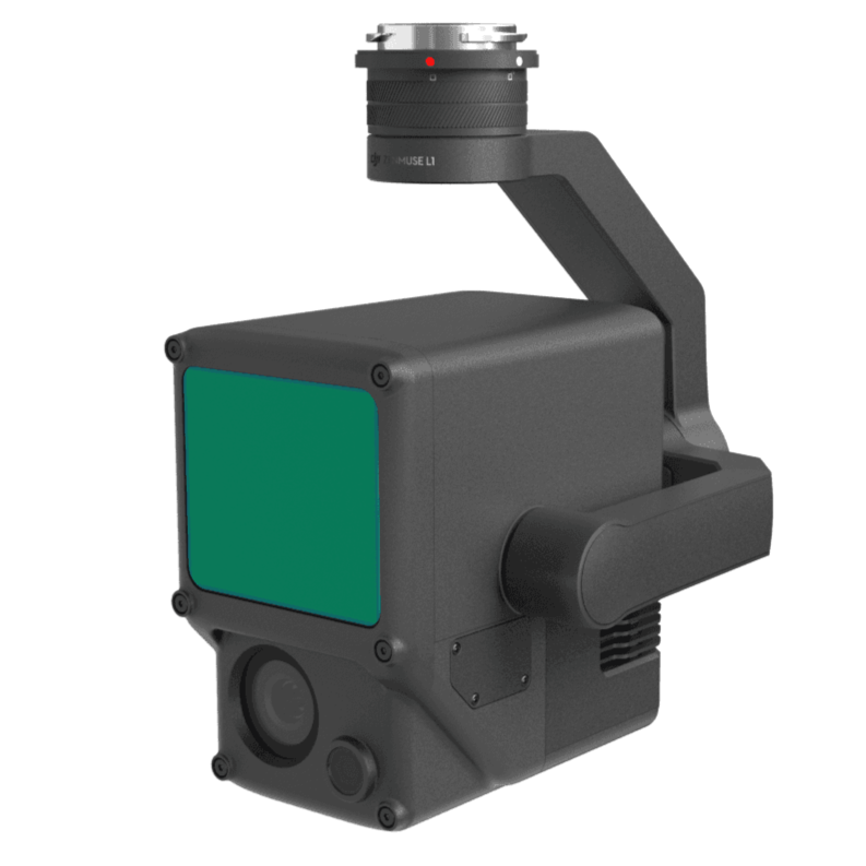


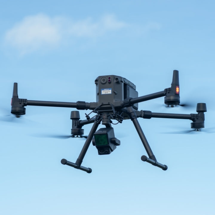
DJI Zenmuse L1
DJI ZENMUSE L1
Efficient, Accurate, Cost-effective LiDAR payload
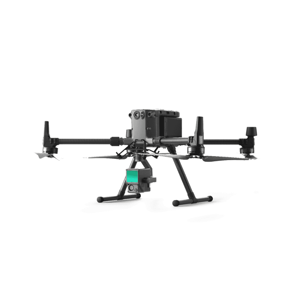
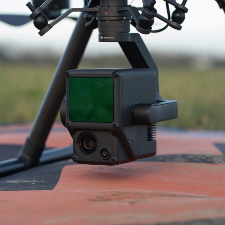
The DJI Zenmuse L1 is a cost-efficient and easy to use enterprise aerial LiDAR payload, engineered for the M300 RTK and M350 RTK.
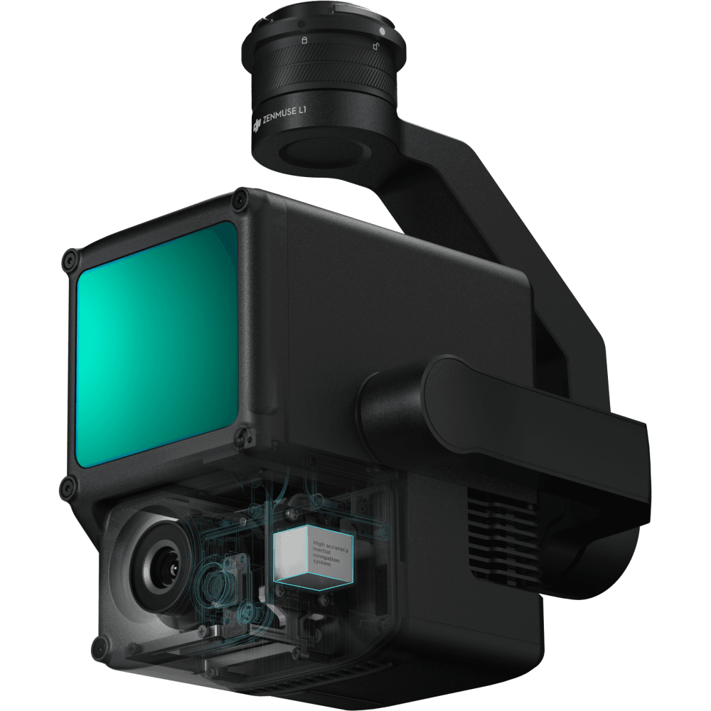
The L1 integrates a Livox sensor, high-precision IMU, a one-inch 20MP CMOS visual camera with mechanical shutter, and 3-axis stabilised gimbal system.
Combine it with the M300 RTK or M350 RTK and the mapping software DJI Terra for a highly-efficient all-in-one aerial LiDAR solution to obtain 3D point clouds for high accuracy and detailed reconstruction.
The L1 can be used across a range of industry verticals, such as energy, AEC, forestry, public safety, and more.
The highlights of the L1 are:
- All-in-one Solution: Integrates a Lidar module, an RGB camera, and a high-accuracy IMU.
- High Accuracy: Vertical - 5cm; Horizontal - 10cm (with 50m flight height).
- Efficient: Cover 2km² in a single flight (flight velocity 10 m/s, flight height 100m, side overlap ratio 20%).
- High Density Point Cloud: 240,000 effective points/s.
- Multiple Returns: Support three returns (Dual and Triple returns to increase the point cloud density to up to 480,000 pts/sec).
- Measurement Range: 450m maximum (80% reflectivity 0 klx).
- Real-time Point Cloud View: Able to display and measure point clouds in real time.
- Weather Resistant: IP54 rating, enabling operators to collect data in rainy or foggy environments.
- DJI Ecosystem: Use DJI Terra for post-processing data.

DJI ZENMUSE L1 And M300 RTK Case Study
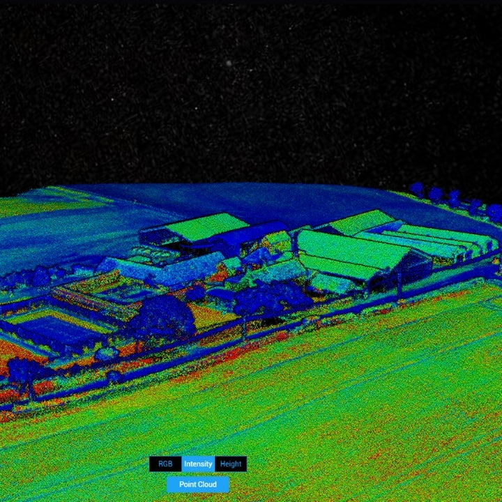
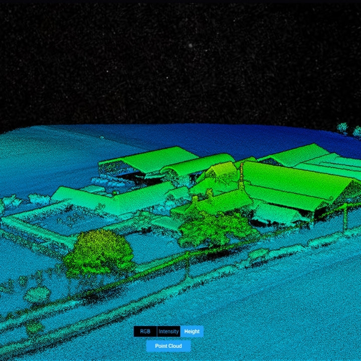
Sample Data Sets.
Dense LiDAR Point Cloud Generation
Exclusive data sets collected by heliguy™ show the quality of the DJI Zenmuse L1 for LiDAR drone surveying, and the power of DJI Terra as a data-processing tool.
Our key findings included:
- Quality Point Clouds: The L1 is capable of creating dense point clouds, like the one pictured. The gimbal was fixed at 90° during the flight. The sides of buildings, for instance, would be more fleshed out by reorienting the gimbal.
- Rapid Processing: Rapid data processing through DJI Terra: Three minutes to process flight data from a 30-minute mission.
- Easy To Use: Autonomous data collection makes the L1 an accessible and simple plug-and-play LiDAR solution.
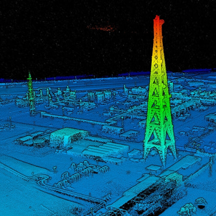
- Detect Intricate Details: The L1 helped to identify intricate details on our point clouds, such as powerlines; features which were not visible in a 2D orthomosaic.
- Dual Camera Solution: The L1 features a LiDAR sensor and an RGB camera. This enables the L1 to output true colour point clouds and reality models. The 20MP RGB camera can be used for photogrammetry, with a ground sample distance (GSD) of 2.74cm at 100 metres of flight height.

Maximise Data Collection
Generate point clouds in real-time.

Streamline LiDAR Missions
The Zenmuse L1 integrates a powerful and ultra-lightweight Livox Lidar module with a 70° FOV, a high-accuracy IMU, and a 20-megapixel camera with a 1-inch CMOS sensor which can be used for photogrammetry missions.
The Zenmuse L1 can generate true-color point cloud models in real-time, or acquire a vast area (up to 2km²) of point cloud data in a single flight.
With a Point Rate of 240,000 points per second and a detection range of 450 meters, the ease and speed of capturing quality Lidar data is unprecedented. Thanks to the L1's ability to support 3 returns, the point rate can be increased to 480,000 pts/sec.
The module supports both Line Scan Mode and Non-repetitive Scanning Mode, a unique technology developed by Livox. This will provide full coverage of the area of interest in a very short amount of time, and allows the sensor to capture data in any direction, instead of along a defined plane.
The Zenmuse L1 Lidar solution can easily penetrate vegetation canopies and foliage.
With an IP54 rating, the L1 can be used in tricky weather conditions, providing more opportunities to collect data.
High Accuracy IMU
Reliable Data Output
The L1's high-accuracy IMU is essential for quality LiDAR data collection.
IMU Accuracy
|
Positioning Accuracy (Vertical) |
RTK: 5 cm |
|
Positioning Accuracy (Horizontal) |
RTK: 5 cm PPK: 2 cm
|
|
IMU Accuracy (Yaw) |
RTK: 0.18° PPK: 0.08°
|
|
IMU Accuracy (Pitch/Roll) |
RTK: 0.03° PPK: 0.025°
|
System Accuracy - System Performance Index
|
Recommended Flight Height |
50-150m |
|
Point Cloud Density |
100-300pts/m^2 |
DJI L1 Additional Features
Payload Health Management System: Built into the DJI Pilot app, the Payload Health Management System records the total use time of the DJI L1, as well as the number of rotation times, error logs, and product maintenance suggestions.
Real-time Awareness Flight: The LiDAR sensor can obtain the aircraft's height above the ground in real-time and perform a terrain awareness flight to ensure data quality and flight safety.
Accuracy Report: After the flight, DJI Pilot will generate an inspection report, view the quality of the point-cloud data, the photo position, number of photos, and the RTK status, so the pilot can confirm the quality of the data on-site.

DJI L1 - Empowering aerial surveys
L1 LiDAR sensor has a range of uses.
Generate Accurate Models And Reconstructions
The DJI L1 is aimed at commercial drone users who are seeking high-accuracy aerial surveying solutions.
The LiDAR sensor can empower clients in energy, AEC, public safety, architecture/heritage, and forestry management.
The L1 is ideal for the following scenarios:
- Topographic Survey: Collect elevation data in a dense vegetation field. The L1 is able to extract Digital Elevation Models (DEM) and Digital Surface Models (DSM).
- Infrastructure Reconstruction: Reconstruct highly-detailed structures such as power lines, and oil and gas pipelines to reduce manned operations - improving efficiency and increasing safety.
- Forestry: Due to the multi-echo capability of the DJI L1, the elevation data in dense forest fields can be easily generated and extracted into DEM and DSM.
- Emergency Mapping Survey: The DJI L1 is capable of capturing real-time, true colour point-cloud models. This provides up to date information for emergency response teams. The IP54-rated L1 can also operate in rainy/foggy conditions, as well as low-light scenarios.

DJI L1 Aerial Surveying Workflow
Harness The Power Of The DJI Ecosystem
Operators can use the DJI ecosystem for an end-to-end LiDAR surveying workflow. This involves the M300 RTK or M350 RTK, the L1 sensor, DJI Terra, and the DJI Pilot app.
- UAS Platform: DJI M300 RTK/M350 RTK drone and L1 payload.
- Ground Control App: DJI Pilot (able to generate point clouds in real-time).
- Post-processing Software: DJI Terra (professional version or above).
- Data Output: 3D point cloud in .LAS format.
Data Acquisition: Plan mission using DJI Pilot app, with a range of mission options available. Make sure the M300 RTK/M350 RTK is connected to RTK network, otherwise DJI Terra will not post-process the captured data.
Data Process: In DJI Terra 'Aerial Photography' task, select the mapping scene as 'LiDAR post-processing', and then select the source folder containing LiDAR IMU and Inertial Navigation Data to start data processing. If the selected folder contains visible light photos, the generated point-cloud file is a visible light point cloud.
DJI L1 Versus DJI Photogrammetry Solutions
How The LiDAR Sensor Compares to the P1 Camera and DJI Phantom 4 RTK
|
Solutions |
Pros |
Cons |
|---|---|---|
|
M300 RTK/M350 RTK + DJI Zenmuse L1 |
• Highly adaptable: Does not rely on lighting conditions or target texture. • Collect elevation data in dense vegetation field. Able to extract DEM and DSM. • High-density modelling on detailed subjects, such as power lines and bridges. Output highly-detailed point-cloud data. • Efficient: Two square miles of ground coverage during a single
flight.
|
• Not suitable for 2D reconstruction use. • Rely on initial POS state.
|
|
M300 RTK/M350 RTK + DJI Zenmuse P1 |
• Multiple Operation Modes: 2D orthomosaic, 3D oblique, corridor, and others. • Efficient: One square mile of 2D orthomosaic coverage during a single flight. • High Accuracy: 1:500 surveying-level accuracy data sets without using ground control points. • High Resolution: 45MP full-frame CMOS. |
• Unable to conduct DEM reconstruction. • Relatively low reconstruction efficiency compared with DJI L1. • Unable to operate at night time and unable to reconstruct areas with no visual texture. |
|
Phantom 4 RTK |
• Low entry barrier, cost-efficient. • Multiple Operation Modes: The GSR app integrates multiple intuitive mission planning modes for different applications and generates waypoints and flight routes automatically with few parameters determined. • Highly-integrated all-in-one form factor, with camera fixed to drone. It is also highly portable. |
• Relatively low operating efficiency compared to the P1. • Lower resolution payload (20MP compared to 45MP on the P1). • Not ideal for large-area operations. • Unable to operate at night time and is unable to reconstruct an area
with no visual texture.
|


