

- View interactive drone 3D model of Lincoln City's LNER Stadium;
- Step-by-step workflow guide to building the model, including data capture parameters, such as flight overlap and flight paths;
- Find out why nadir and oblique flights are recommended for 3D models and how additional manual flights provide extra detail;
- Advantages of using drones for 3D models and how these digital assets can benefit a range of industries.
This interactive dataset of Lincoln City's LNER Stadium shows the benefit of deploying drones for 3D modelling.
Use your mouse to navigate the model in the panel above, or click this link to open it in a separate tab.
3D models are highly-detailed digital assets that provide realistic and accurate representations of their real-world counterparts - as demonstrated by the image below.

Georeferenced 3D models can be used for planning, analysis, calculations, and enhanced decision-making - benefiting industries such as AEC, public safety, oil and gas, and heritage conservation.
And drones enable teams to collect this data quickly, safely, and accurately.
This blog will look at the process of building 3D models with drone data - with a specific focus on photogrammetry workflows - and will use the Lincoln City dataset as an example.
The 3D model of the LNER Stadium was collected with the help of the heliguy™ in-house geospatial team during a drone surveying course with the Lincolnshire Resilience Forum.
Benefits Of Using A Drone For 3D Models
Using a drone for 3D modelling offers several advantages over traditional methods of data capture.
| Benefit | Reasons |
| Efficiency & Speed | Drones can rapidly capture large areas from the air, significantly reducing the time required for data collection compared to traditional ground-based methods. This efficiency is crucial for projects that demand timely and frequent updates. |
| Cost-Effective | Drone 3D modelling can be more cost-effective than traditional surveying or mapping methods. Drones eliminate the need for expensive manned aircraft or extensive ground-based equipment. |
| Accessibility | Drones reach locations that are challenging or hazardous for humans to access, such as steep terrains, construction sites, or areas affected by natural disasters. |
| High-Resolution Imaging | High-resolution cameras capture detailed imagery that contributes to the creation of accurate and realistic 3D models. |
Industries That Can Benefit From Drone 3D Models
A range of industries can benefit from 3D drone photogrammetry models.
| Industry | Benefits |
| Construction | A 3D model in the construction industry enhances project visualisation, improves earthworks calculations/projections, streamlines communication, and improves decision-making by providing stakeholders with an accurate and detailed representation of the project. This helps planning, coordination, and identifying potential issues before they arise. |
| Inspection | A 3D model for inspection purposes provides a comprehensive and detailed digital representation, allowing inspectors to remotely analyse structures, identify defects, and assess conditions with precision, enhancing efficiency and safety in inspection processes. |
| Oil And Gas | A 3D model in the oil and gas sector facilitates accurate asset visualisation, aiding in the planning, monitoring, and maintenance of infrastructure, while also improving safety by enabling remote inspections and assessments of facilities and pipelines. |
| Public Safety | A 3D model for public safety can be used for crime-scene investigation, road traffic accidents, evidence gathering, and planning/responding to an emergency situation. It helps contribute to more effective and coordinated responses. |
| Heritage Conservation | A 3D model in heritage conservation provides a digital preservation of historical artifacts and structures, enabling meticulous documentation, analysis, and restoration planning while minimising physical interventions, thereby ensuring the long-term preservation of cultural heritage. |
| Land Surveying | A 3D model in land surveying enhances accuracy and efficiency by providing a comprehensive and detailed representation of terrain, boundaries, and topography, enabling surveyors to make informed decisions, streamline planning, and optimise land development projects with precision. |
Drone 3D Modelling Case Study: Mapping Lincoln City's LNER Stadium
So, how did the heliguy™ in-house geospatial team build the 3D model of Lincoln City's LNER Stadium?

The table below provides an overview of some of the mission parameters and details.
| Drone And Camera | DJI M300 RTK and DJI Zenmuse P1 |
| Types Of Flight | Nadir Oblique (Smart Oblique) Manual |
| Number Of Photos | 1,401 |
| Data Processing Software | DJI Terra |
| Processing Time | 8 hours (approx) |
Drone And Camera
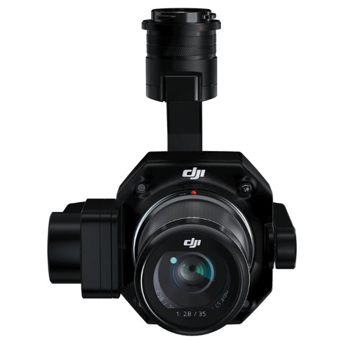
A quality camera is important for capturing data for a robust 3D model, so we deployed the DJI Zenmuse P1 photogrammetry camera, equipped with a 45MP full-frame sensor.
This was integrated with the DJI M300 RTK drone. The P1 is also compatible with the DJI M350 RTK.
Flight Paths
We conducted three types of flights:
- Nadir
- Oblique
- Manual
These are demonstrated in the image below, showing nadir at the top, oblique in the middle, and manual at the bottom.

Nadir And Oblique Drone Mapping
The nadir flight - conducted at 100m altitude - and oblique missions were flown with the following overlap:
- Side overlap: 70%
- Front overlap: 80%
Overlapping picture intervals in photogrammetry data collection is essential for improving accuracy, mitigating errors, enhancing feature matching, and ensuring the reliability of the resulting 3D model.
The table below outlines the benefits of conducting nadir and oblique flights for drone 3D modelling.
| Data Collection Method | What Is It? | Benefits |
| Nadir | The camera or sensor is pointed directly downward, capturing images or data perpendicular to the Earth's surface. |
• Minimises distortions and makes it easier to create precise maps and 3D models. • Helps maintain a consistent scale across the entire image or map. This is important for accurate measurements and comparisons. • Provides a uniform Ground Sampling Distance (GSD) across the entire area being surveyed. |
| Oblique | Capturing aerial imagery or data at an angle, rather than directly perpendicular to the Earth's surface. The camera or sensor is tilted at an angle relative to the nadir (straight-down) perspective. |
• Angled view captures images of features on the ground from multiple directions, providing multiple perspectives. • Enhances the visualisation of structures, buildings, and landscapes by showing them from different angles. • Allows for the capture of vertical and near-vertical surfaces, providing additional information for applications such as urban planning, architecture, and disaster response. • Multiple perspectives aid in the generation of detailed and realistic 3D representations. |
The images below demonstrate the different views that nadir and oblique provide - based on the same location of the ground.
Nadir provides this top-down view...

...while oblique offers this angled view.

For 3D modelling, a hybrid approach comprising both practises is recommended: Providing the benefits of an overall context from nadir views while also capturing detailed information from oblique angles.
Another advantage of deploying the P1 is its ability to conduct Smart Oblique mapping missions.
This presents a more efficient form of oblique drone mapping. The gimbal automatically rotates to take photos at the different angles needed. Only photos essential to the reconstruction will be taken at the edge of the flight area, increasing the efficiency of post-processing.
Manual Imaging
A number of manual flights were conducted at Lincoln to collect higher-resolution imagery to supplement the automated data.
The flights were conducted slowly with timed interval shots every two seconds. The gimbal was switched to different positions throughout, as shown by the two images below.


Manual image capture provides greater control over certain aspects of the data collection process, and can result in the collection of higher-resolution imagery.
The resulting data speaks for itself.
Compare the quality of these two stands, where manual flights were conducted...


...compared to these two, where manual flights were not flown.

In this stand, for instance, the quality is so good, the signage at the back can be read clearly when zooming in on the model...

...compared to this stand, which is warped in places and lacking detail.

And in this example, the stairs and seats are more complete in the stand where manual imagery was captured...

...compared to this one.

And look at the quality of the flags, where manual data capture was deployed.


These examples show the value of capturing manual imagery to help construct highly-detailed 3D models.
Data Processing
A total of 1,401 photographs were taken during the nadir, smart oblique, and manual flights.
This data was processed through DJI Terra, taking around eight hours.
This was conducted on a computer with a top-end NVIDIA graphics card and 32GB of RAM. Therefore, timeframes are dependent on the specifications of each computer.
The model was uploaded to Esri ArcGIS Pro to produce a video flythrough.
Best Drones And Drone Cameras For 3D Modelling
As mentioned previously, we deployed the DJI M300 RTK and P1 for the flights at Lincoln.
This set up was used to create this 3D model of a heritage site in Northumberland, England.

However, other options include:
DJI Mavic 3 Enterprise
The DJI Mavic 3 Enterprise is a portable surveying option, featuring a 4/3 CMOS sensor with mechanical shutter and 20MP resolution.
It can yield 3D models such as this:

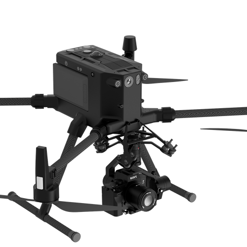
Gremsy Gimbal
The Gremsy Pixy SM is a high-end precision mapping gimbal designed to integrate the full-frame, mirrorless 61MP Sony a7R IV with the DJI M300 RTK drone. It can produce high-quality 3D models, such as this below:

Summary
3D models are an important digital asset for a range of industries, providing rich and realistic visualisations.
Drones enable this data to be captured efficiently, safely, and accurately.
By following the workflow methods set out in this guide, you can ensure your models are highly detailed and data rich.
Contact our in-house geospatial team to discuss drone solutions and drone surveying practices.

Leave a comment