Sold Out
Emlid Reach RS+ GNSS Receiver

Emlid Reach RS+ GNSS Receiver

SKU: RCH202

£774.99 Regular price
/
Tax included in UK  & Free Delivery
Notify Me When Available

What's in the Box

Take a look

Updated on variant change.

Explore what's inside the box.

Need advice on this product?

Ask a Question

Our experts are on hand to help you.

When You Spend £99

Free Next Working Day Delivery

Saturday Delivery Also available.

Emlid Reach RS+ GNSS Receiver

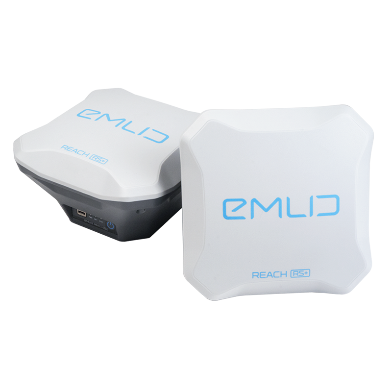
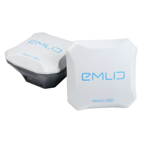
High-precision single-band GNSS receiver

The Reach RS+ is a high-precision single-band GNSS receiver, providing 1cm accuracy.

It can be used for RTK and PPK data collection.

The Reach RS+ is shockproof, has IP67 water and dust protection and works all day on one charge with an industrial battery that doesn't die on cold.

This high-precision receiver can be deployed in numerous ways, including marking spots for piles on construction sites, to place ground control points, and laying out archeological sites.

It can be used in conjunction with the Emlid Flow app, to collect and stake out points and control all features of the device. 

The Reach RS+ is a powerful yet cost-effective solution, compared to other receivers on the market.

Emlid RS+ Key Features

Powerful, portable, weatherproof

The Emlid RS+ is packed with features to make it an industry-leading solution. These include:


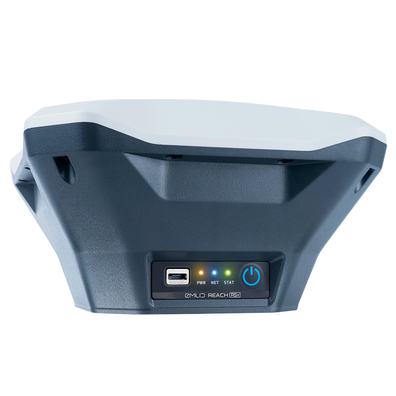
Multi-support System: Tracks GPS, GLONASS, BeiDou, Galileo, QZSS, and SBAS.

Long-range Radio: LoRa with frequency range 868/915MHz for reliable connection with distances of up to 8km.

Dual-feed Antenna: With tight phase centre variation.

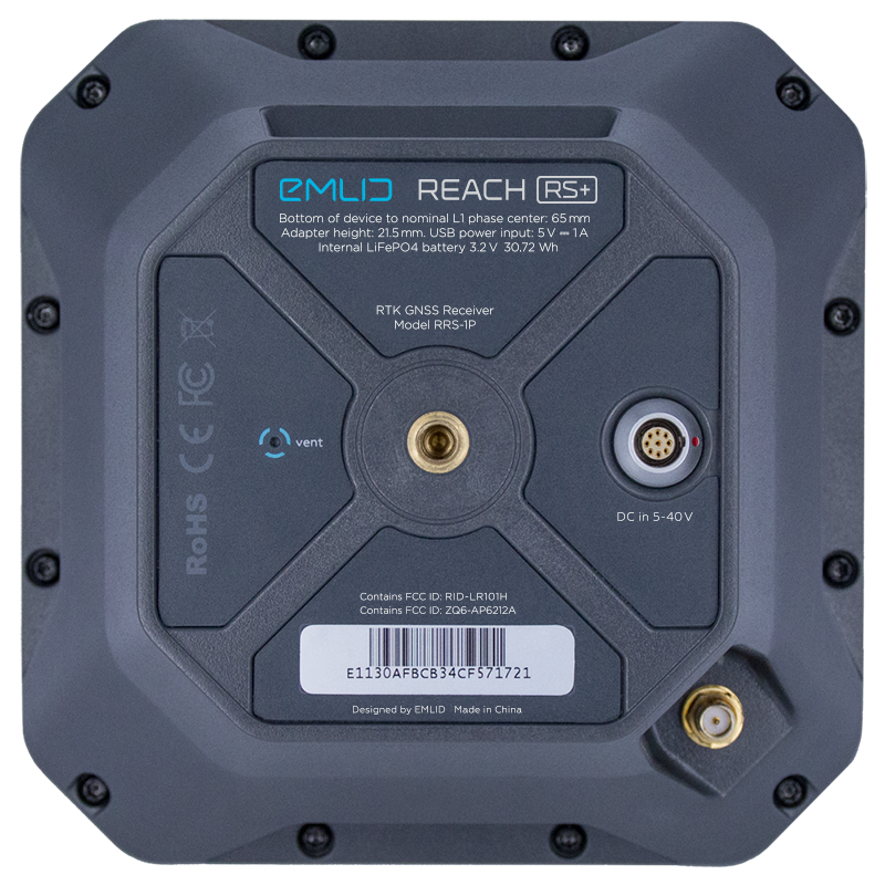
Polycarbonate Body: The Reach RS+ is durable and impact resistant. Its body is made of polycarbonate - an extremely durable material that is used in bulletproof glass.

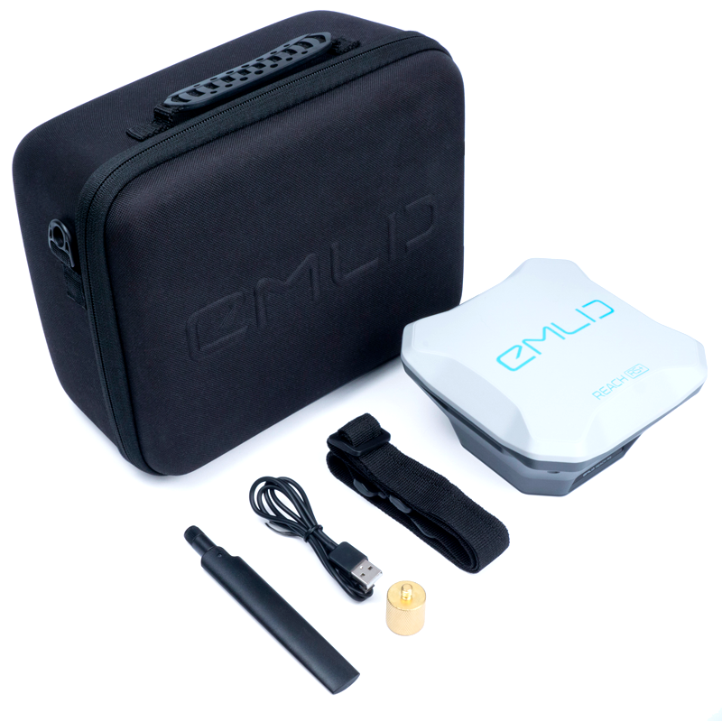
30-hour Battery: LiFePO4 battery; external 6–40 V input; charges over USB from a powerbank.

Water and Dustproof: IP67: Work in dusty areas or under the rain. Rugged and hardy, the Reach RS+ can operate in temperatures from -20°С to 65°С.

8GB of Storage: Built-in memory for logs.

PPK System for UAV Mapping

Use fewer GCPs with centimetre accuracy

Reach logs precise tracks and the exact moment when each photo is taken.

The time and coordinates of each photo are logged with a resolution of less than a microsecond.

This means that the number of checkpoints can be reduced - and allows GCPs to be used only to check your accuracy - and enables the creation of precise 3D models.

Connectivity

The Emlid Reach RS+ provides seamless connectivity.

Reach needs corrections from a base station to calculate centimetre-precise coordinates in PPK and RTK.

Use Reach with another Reach receiver or an NTRIP service. VRS is also supported.

Reach M2 and M+ work seamlessly with other Reach receivers - such as Reach RS2 and RS+ - over any link and are compatible with any other receiver that supports RTCM3 and NTRIP.

Compatibility

Use Reach RS+ to set up your own base station. Stream corrections over the network via NTRIP/TCP or LoRa radio. Record base logs for post-processing.

Correction format: RTCM3
Log format: RINEX 2.0, RINEX 3.0

Max distance from a base: Up to 10 km in RTK; Up to 20 km in PPK.

Reach RS+ works seamlessly with other Reach receivers over any link.

Machinery Guidance

Reach RS+ provides precise coordinates over Bluetooth/Wi-Fi to your tablet with a lightbar navigation app.

The RS-232 interface allows the connection of the Reach RS+ directly to an autosteer system.

Solution formats: NMEA, LLH/XYZ
Compatible apps: AgriBus-Navi, and Efarmer

UAV Mapping Kits: Reach M2 Vs Reach M+

Both solutions are available as stand alone modules or as part of dedicated UAV mapping kits.

The Reach M2 UAV mapping kit features: Reach M2, Reach RS2, GNSS antenna and accessories.

The Reach M+ UAV mapping kit features: Reach M+, Reach RS+, GNSS antenna and accessories.

Emlid Flow

Emlid Flow is a mobile app for land surveying, which can be used in conjunction with Emlid’s ecosystem of GNSS receivers.

It is an upgraded version of the ReachView 3 app, with new features and the Flow 360 cloud service.

Key features include:

  • Linework and coding
  • Geoids, grid shifts, custom coordinate systems
  • Stake out points and lines
  • Base and rover configuration
  • Reach receiver monitoring for information on satellite reception, solution status, corrections stream state and battery charge level
  • Manage NTRIP profiles
  • Raw data logging (RINEX files for PPK workflows)

The app is synchronised with the cloud-based Emlid Flow 360. It allows you to access and manage your survey data from the browser at flow360.emlid.com.

With Emlid Flow 360, you can prepare for the fieldwork from the comfort of your office: Create a project, configure the coordinate system, choose a code library or upload a new one, or just import all the necessary data.

Guide to Emlid Flow

Emlid Flow And Emlid Flow 360 Licence Plans

Two packages are available for Emlid Flow and Emlid Flow 360: Standard and Survey.

The Standard version is free and emulates the features previously accessible in the ReachView 3 app.

To access the new features - such as linework and coding - in addition to what is included in the Standard package, upgrade to the paid-for Survey licence.

Existing installations of ReachView 3 will automatically update to Emlid Flow with the Standard subscription plan.

Standard Survey
Emlid Flow
Collect and stake out points
Choose coordinate systems, geoids, and grid shifts
Add custom coordinate system
Export and import in CSV, DXF, SHP
Control your Reach receivers
Use a built-in NTRIP client
Collect and stake out lines X
Add codes on the go X
Switch to a satellite map X
Emlid Flow 360
Manage projects with the app
Export and import in CSV, DXF, SHP
Add custom code libraries X
Price Free forever Starting from £20 per month
How To Subscribe No account is needed: Sign up for free Free Emlid account is needed: Free 14-day trial available

Product specification

Emlid Reach RS+ GNSS Receiver

Emlid Reach RS+ Product Specification

SpecificationValue
Mechanical
Ingress ProtectionIP67
Dimensions145 x 145 x 85mm
Weight690g
Operating Temperature-20°С to +65°С
Electrical
AutonomyUp to 30 hours
ChargingMicro USB 5 V
External Power Input6–40V
CertificationFCC, CE
BatteryLiFePO4 3.2 V
GNSS
SignalsGPS/QZSS L1, GLONASS G1,
BeiDou B1, Galileo E1, SBAS
GPS / GNSS14Hz / 5Hz
Number of Channels72
IMU9DOF
Positioning
Static Horizontal 5mm + 1ppm
Static Vertical10mm + 2ppm
Kinematic Horizontal7mm + 1ppm
Kinematic Vertical14mm + 2ppm
Data
CorrectionsNTRIP, RTCM3
Position OutputNMEA, LLH/XYZ
Data LoggingRINEX with events;
Up to 14 Hz
Internal Storage8 GB
Connectivty
LoRa RadioUp to 8km;
868 / 915MHz
Wi-Fi802.11 b/g/n
Bluetooth4.0/2.1 EDR
PortsRS-232, Micro USB