

Ground-breaking drone-detection technology is available to monitor and spot UAVs - which could potentially stop major incidents like the recent disruption at Gatwick Airport.
The DJI AeroScope system is a sophisticated and comprehensive platform that rapidly identifies UAV communication links, gathering real-time information such as flight status, paths, serial number, speed, direction and
North East-based drone expert heliguy™ is a specialist in AeroScope. Just last month, the company was specially selected to support Chinese technology giant DJI with the AeroScope system during a ground-breaking demonstration - entitled Operation Zenith - to show how it can be a key element in
Operation Zenith showed that DJI’s AeroScope can be a valuable part of a UTM system by monitoring and tracking airborne drones around sensitive locations, reliably and rapidly feeding that information to an integrated airspace manager, and enabling a flexible model that adapts instantly to new information about aerial operations.
Brendan Schulman, DJI Vice President of Policy and Legal Affairs
Another effective form of drone detection is utilising a layered approach, bringing in a number of different solutions to create an all-encompassing defence strategy. heliguy™ has entered into an exclusive partnership with Operational Solutions (OSL) to offer a comprehensive package, which incorporates AeroScope, alongside a mix of radar, cameras and sophisticated software.
In the wake of what has happened at Gatwick Airport - after drone sightings have triggered disruption - heliguy™ is offering to showcase the AeroScope technology to interested airports and emergency services.
What is AeroScope
A DJI AeroScope unit is used to detect drones flying in a specific area. Once a drone is located, AeroScope can be used to track the real-time and historical telemetry data of the aircraft whilst powered on and flying in the range of the AeroScope unit.
AeroScope tracks drones through the signal between the aircraft and its remote controller.

If a drone is located in an area, several pieces of information will be given. Information includes the drone location, altitude, speed, direction, takeoff location, operator location, model, serial number and the email address used for drone registration. The email address can be used to contact the pilot whenever follow-up is required. The use of the existing signal between the drone and remote controller means existing kit requires no changes to be tracked.
DJI developed AeroScope to help protect sensitive airspace and to prevent any kind of accidents or unauthorised flights.
AeroScope can identify the vast majority of popular drones on the market exceptionally quickly, giving organisations all the information they need in real-time to make informed security decisions about drone pilots in their airspace.

This data can help prevent accidental drone collisions and ensure that all drone pilots are acting within the regulations in place in any given area.
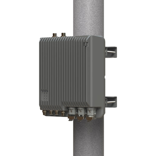
There are two types of AeroScope unit - Stationary and Portable.
Stationary AeroScope unit

The Stationary AeroScope unit is designed to be in continuous use outdoors and has an IP65 Ingress Protection.
One of the most significant advantages of using the Stationary unit is the ability to customise and configure the unit precisely to the site that needs to be monitored.
In ideal conditions, a Stationary AeroScope setup has a range of 50km - and can identify drones in a little as two seconds.
There are a number of deployment options too, meaning the data gathered by AeroScope can be hosted on a private cloud for particularly sensitive airspace.
It also allows you to integrate with other security systems to provide a more complete picture of the monitored airspace.
The Stationary DJI AeroScope provides a flexible platform for drone detection.
There are two antenna configuration options available. These are:
- G8 Antenna
- G16 Antenna
Both antennas are directional, but the higher gain G16 antenna provides the highest gain.
The Stationary AeroScope is water-proofed, dust-proofed and can be used in a huge range of temperatures and humidity levels.
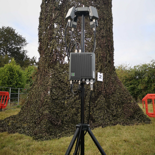
Portable AeroScope unit

The Portable AeroScope unit can be set up quickly and easily anywhere it's needed.
It's perfect for use at temporary events, mobile deployments or other instances where you need to protect the airspace around you at short notice.
This system gives you all the AeroScope functionality in a single portable case. The antenna, control screen and TB50 batteries, which power the unit, are all integrated.
In emergencies, the AeroScope Portable system can boot up almost immediately.
How is DJI AeroScope managed?
DJI has created a bespoke piece of software called AeroScope Backstage to help manage the AeroScope installation.
Available as a cloud-based app or on the AeroScope portable unit, the Backstage Management is a central interface to manage the data that AeroScope provides.

There are a number of tools available in Backstage, including monitoring, command and investigation tools. All of these assist operators in protecting their airspace effectively.
An SDK is also available, meaning that the Backstage Management app can be customised or integrated with other systems based on the needs of the operator.
Drone detection - A layered solution
To take drone detection to the next level and to have a comprehensive and all-encompassing strategy, a layered solution is an extremely effective cause of action. Our exclusive partnership with Operational Solutions (OSL) allows us to offer this incredibly capable set up.
Harnessing the power of multiple systems - including DJI AeroScope - this integrated approach offers a complete detection package.

This integrated solution features AeroScope, working in tandem with the OSL Face interface - a one-stop-shop piece of visual software. This intelligent platform integrates all radars onto one map - eliminating the need for multiple computer monitors in an easy-to-use format.
To take your drone defence even further, the advanced Robin ELVIRA can be integrated into this layered solution and is the final piece in the jigsaw.
ELVIRA is a purpose-built drone detection and tracking tool, combining smart software with affordable radar, offering a large coverage area.
The set-up options for this layered drone-detection solution are:
AeroScope Mobile +
A portable drone-detection kit
Includes:
1 x AeroScope Mobile Unit
OSL Face Interface
1 x RGB Camera
1 x Infrared Camera
AeroScope G8 +
A large-scale drone-detection solution
Includes:
1 x AeroScope G8 Unit
OSL Face Interface
1 x RGB Camera
1 x Infrared Camera
1 x Robin ELVIRA
AeroScope G16 +
The ultimate drone-detection setup
Includes:
1 x AeroScope G16 Unit
OSL Face Interface
2 x RGB Camera
2 x Infrared Camera
1 x Robin ELVIRA
To inquire about these solution options, click here.
Operation Zenith
The incident at Gatwick comes a month after a world-first demonstration to test how drones and traditional aircraft can safely share the same airspace. As mentioned previously, AeroScope was showcased at the event.

Codenamed Operation Zenith, the demonstration featured ground-breaking live-action scenarios at Manchester Airport to offer a glimpse into what was described as ‘a new and exciting future’ of air-traffic management.
The special event was led by aviation technology company Altitude Angel, as well as Manchester Airport and NATS – which provides safe and efficient air-traffic services and innovative solutions to

Operation Zenith was supported by a series of government, industry and academic participants, including DJI, Vodafone, the National Police Air Service, DEFRA and heliguy™.
During Operation Zenith, Heliguy set up a G8 antenna.
It was a massive coup and a fantastic opportunity for heliguy™ to be involved with a lot of key players in the industry, such as Altitude Angel and NATS, to create this fantastic network of lots of different technologies to ensure the safety of UK airspace. Operation Zenith was the first step towards a new and exciting future involving the integration of manned and unmanned aviation.
Kevin Morton, Heliguy’s head of technical works
He added: “The event went really well. It went without hitch and everything came together. DJI came to us to provide AeroScope support as we are a specialist in this field and DJI knew from previous dealings with us that we know our stuff when it comes to AeroScope.”
AeroScope is already in use at some airports, major public arenas and large public gatherings around the world. Because it receives signals directly from drones using their existing communications link, rather than relying on a wireless network or special transmitters, it is ideal for capturing critical airspace information for a UTM system to process.

Leave a comment