LiDAR is a remote sensing technology that uses rapid laser pulses to map out the shape of the earth and
its surface characteristics.
These precise measurements can then be used to create 3D models and maps of objects and environments.
Pairing a LiDAR scanner with a drone makes LiDAR more accessible, and allows surveyors and other
iprofessionals to collect precise data, quickly, efficiently, and safely.
As a result, LiDAR sensors are being deployed across a range of industries, such as construction,
infrastrucutre, mining, public safety, urban planning, archaeology, forestry, and agriculture.
How Does LiDAR Work?
LiDAR is similar to radar and sonar, but it uses light waves from a laser fired from a sensor or scanner,
instead of radio or sound waves.
A LiDAR system calculates how long it takes for the light to hit an object or surface and then reflect
back to the scanner.
The distance is then calculated using the velocity of light (299,792,458 metres per second). These are
known as Time of Flight measurements.
This gives an accurate positioning point of where the laser hit. Depending on the sensor used, LiDAR
units can blast hundreds of thousands of pulses per second, helping to build up a detailed visualisation
of what the sensor is focusing on.
Each of these measurements, or returns, can then be processed into a 3D visualisation known as a point
cloud.
"Scanning from safe, secure locations we get
amazingly accurate 3D scans of old stopes, tunnels and
other mine areas that are unsafe for entry."
Robert Carrington -
Newrange Gold Corp
"In 45 minutes of flying, the LiDAR team accomplished a decade’s worth
of archaeological survey. We have the tools and technology to understand our planet like never
before."
LiDAR is an active system that uses ultraviolet, near-infrared light to image objects requiring no
external light for effective mapping. This means it can be used in the dark.
LiDAR surveying is extremely precise. It is particularly useful for mapping small features, such as
high-voltage power lines.
Not only is LiDAR data accurate, it can also collect dense geo-referenced point cloud data.
When integrated with a drone, LiDAR sensing is a fast and efficient aerial surveying solution -
covering large areas quickly and improving safety.
LiDAR point clouds can be used to create 3D Digital Elevation Models of terrains, 3D Digital Surface
Models, and 3D Models of buildings or industrial objects - benefiting a range of industrial and
commercial applications.
LiDAR has the ability to penetrate through multiple layers, such as a tree canopy, to see all the
way to the ground. In traditional photogrammetry, vegetation can stop you from acquiring an accurate
representation of what the ground topography looks like.
LiDAR is a particularly popular tool for capturing the built environment, (such as buildings, road
networks and railways).
It can also create digital terrain (DTM) and elevation models (DEMs) of specific landscapes.
Digital Elevation Models (DEM): Bare earth (topographic)
models of the Earth’s surface. DEM allows you to generate slop (rise and fall in degrees or
percent), aspect (slope direction), and hillshade (grayscale 3D representation of the surface,
with the sun's relative position taken into account for shading the image).
Digital Terrain Models (DTM): A 3D representation of a terrain surface.
DTMs include contours, as well as features such as rivers, ridge lines, etc.
Digital Surface Models (DSM): Incorporates elevations from natural and
built surfaces, such as buildings, tree canopy, and powerlines. Essentially, a DSM represents
the earth's surface and all objects on it.
LiDAR By Industry
How LiDAR is used across different industries.
LiDAR can benefit a range of missions, but it is typically used for surveying, as it can capture quick
and accurate data which can be converted into detailed 3D models.
Construction/Infrastructure
LiDAR can be used to benefit construction and infrastructure projects, creating 3D models and producing
digital twins ideal for BIM applications.
These digital models can be used throughout the lifecycle of a project, allowing teams to scan for
quality assurance, cross-check models and spot errors before they become a problem, conduct stockpile
volumes, and monitor the progress of a development.
All of this information can then be shared quickly and easily with stakeholders and team members to
improve communication.
This helps to drive efficiency, reduce costs, improve safety, and allow architectural design to be pushed
to its limit.
Public Safety/Disaster Response
LiDAR has fast become a useful tool for public safety crews.
It is particularly useful for producing collision mapping and providing 3D forensic data - especially
when an incident occurs at night.
Using LiDAR enables quick evidence collection; particularly useful after an RTC to help with a quick
clear-up - freeing up commuters, and saving money on accident personnel. Evidence gathered can also be
used in court.
LiDAR can also be used for disaster response/risk assessment. Visualisation of a LiDAR point cloud allows
emergency responders to easily identify areas most affected by a disaster and understand terrain
mobility. In some cases, this 3D view of a situation can provide unique information.
Agriculture and Forestry
LiDAR has a lot of use cases for environmental applications, including agriculture and forestry.
LiDAR can measure canopy heights, tree density, and location/heights of individual trees.
One of the key advantages of LiDAR is that it can be used in densely vegetated areas. While it can not
penetrate vegetation, it can peer through the gaps in the leaves and collect multiple
hits/returns.
LiDAR can also be used to highlight changes, such as surface degradation and vegetation growth.
In agriculture, LiDAR can be used to map out slope variations and provide increased yields through
detailed monitoring.
Mining
LiDAR provides many benefits for mining, yielding precise inventory information, and accurate pit models
and contour maps.
The advantage of LiDAR is that it can reveal the diverse variations in elevation, and provide geospatial
information of the natural surface, mine infrastructure, and production volumes.
Covering areas quickly, a drone with LiDAR improves the efficiency of mining operations, and, as it can
reach dangerous areas, it vastly improves safety.
For these reasons, LiDAR can be utilised for an entire lifecycle of a mining venture, from evaluating a
pre-mine site, through to operating a mine, and the post-mine process.
Archaeology
LiDAR has revolutionised archaeology, making it possible to measure and map objects and structures that
might otherwise remain hidden.
For example, in the early 2010s, archaeologists were left astonished after LiDAR sensing revealed a
lost Maya city.
Another project saw researchers deploy LiDAR to spot more than 20,000 archaeological features in Mexico,
which had been home to an ancient city.
LiDAR can also be used by archaeologists and conservationists to map structures that have already been
found, such as Notre Dame Cathedral.
Urban Planning
Thanks to its accuracy, LiDAR is an effective method for urban planners, helping to create 3D city models
to help examine and identify issues in current urban areas and build cities for the future.
LiDAR point clouds can be used for mapping entire cities, helping to pinpoint structures or areas of
interest in precise detail, while features such as road networks, bridges, and street furniture can be
classified and extracted.
3D models can be useful for a range of purposes, such as mapping buildings and their heights, simulating
new buildings, updating map data, emergency response planning, monitoring traffic, flood modelling, and
detecting urban environment changes.
LiDAR mapping uses a laser scanning system with an integrated Inertial Measurement Unit (IMU) and GNSS
receiver. This allows each measurement, or point in the resulting point cloud, to be georeferenced. Each
‘point’ combines to create a 3D representation of the target object or area.
LiDAR maps can be used to give positional accuracy – both absolute and relative, to allow viewers of the
data to know where in the world the data was collected and how each point relates to objects terms of
distance.
Traditionally, LiDAR technology was large and expensive. For all of its benefits, the steep price tag and
bulky modules made entry into the LiDAR market difficult. But this is changing.
More compact and affordable solutions are now available, empowering more professionals to take advantage
of the technology.
And when paired with a drone, a LiDAR sensor can help surveyors and other users capture data extremely
efficiently and safely.
Below are some of the options available.
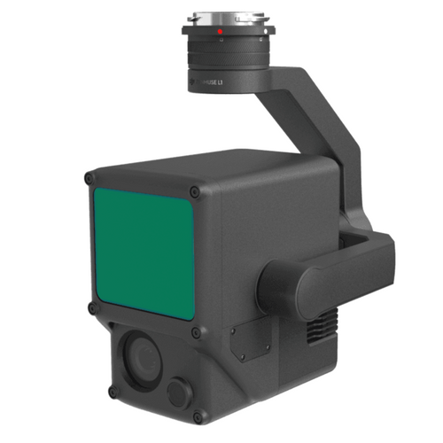
DJI L1 Drone LiDAR Sensor
The DJI L1 integrates a LiDAR module and 20MP RGB camera, along with a high-accuracy IMU.
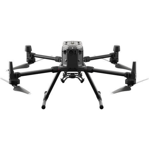
Engineered exclusively for the DJI M300 RTK drone, the L1 is a robust and efficient LiDAR solution, able
to cover up to 2km² in a single flight and capable of achieving accuracies of 5cm (vertical) and 10cm
(horizontal) at 50m flight altitude.
With a point rate of 240,000 points per second, which can be increased thanks to the L1's ability to
support up to 3 returns, the L1 can be used to create highly detailed and dense point clouds.
Use Point Cloud LiveView to obtain real-time point clouds, while the RGB camera helps to give colour to
your data. The RGB camera can also be used for photogrammetry missions.
The L1 is a rugged LiDAR solution, thanks to its IP44 rating, ensuring a reliable performance in
difficult weather conditions and enabling more opportunities to capture data.
The L1 can be used in conjunction with drone survey software package, DJI Terra, for an end-to-end
surveying solution within the DJI ecosystem.
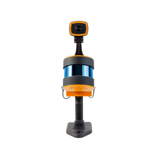
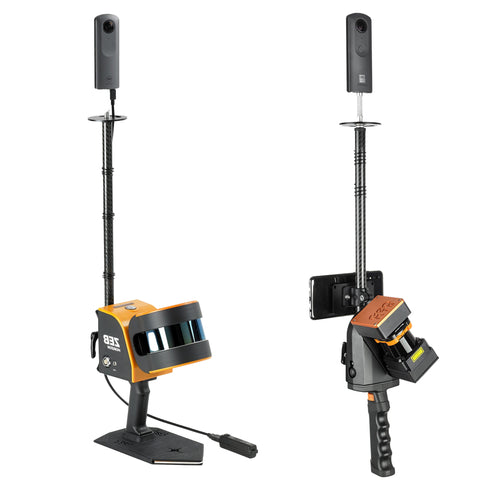
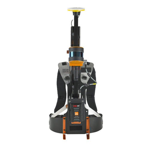
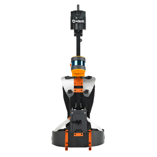
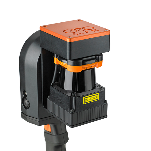
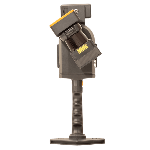
HELIGUY.com™ has partnered with geospatial technology expert GeoSLAM to provide drone LiDAR solutions,
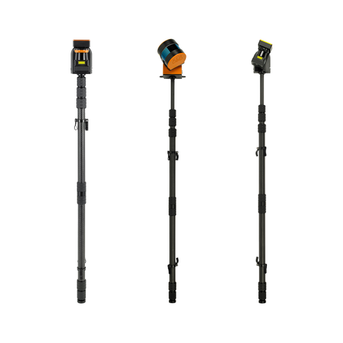
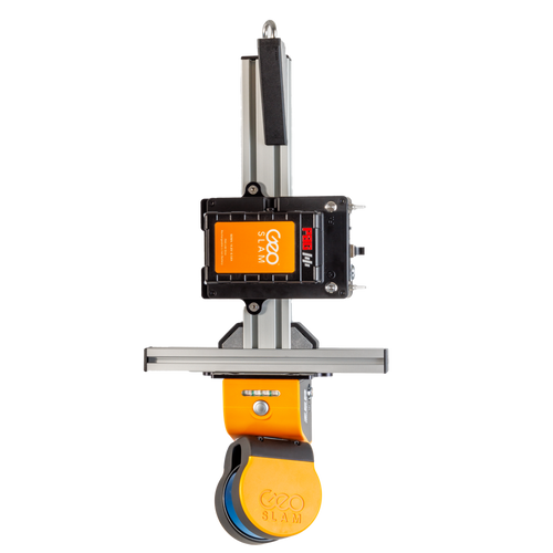
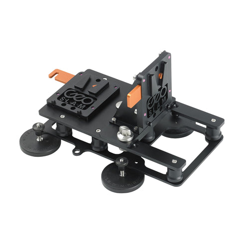
adding the ZEB Horizon 3D scanner to our product portfolio.
The ZEB Horizon can be integrated with a DJI M600 via a UAV mount and can collect highly-detailed LiDAR
point clouds.
This lightweight and compact aerial mapping technology has a range of 100m and can capture 300,000 points
per second with an accuracy of 1-3cm.
It can be used in remote areas with poor GPS and enables operators to capture data for 3D modelling,
conduct material volume and tonnage calculations, and collect floorplan and building measurements.
The ZEB Horizon can be utilised for a range of missions, including forestry, power lines, railways,
farming, mining, and construction sites.
Data collected from ZEB Horizon can be processed using GeoSlam Hub and Draw, turning your 3D data into
actionable information and valuable deliverables in minutes.
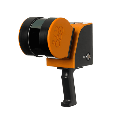
Livox Technology Company Limited is an independent company founded in 2016 through DJI’s Open
Innovation Program.
Committed to helping customers incorporate LiDAR sensors into efficient commercialisation of their
projects, Livox has released a number of LiDAR sensors, including the industrial-grade Mid
series.
The Livox Mid is a compact and high-performance LiDAR sensor, with a 260-metre detection range. It
can achieve 2cm precision, and a vertical and horizontal accuracy right down to 0.1°. It is suitable
for a range of applications, including mapping and robotics.
At AirWorks 2020, Livox announced the imminent release of the Livox Avia, which will be compatible
with the DJI M300 RTK and M200 Series of drones.
This compact solution, designed for easy integration, will be sub 500 grams, have a wide 70-degree
FOV, and a detection range of up to 500 metres. It will be able to create high-density point clouds
and support up to three returns.
"The mapping industry has been limited by the price and weight of LiDAR
for a long time. As a pioneer who makes large-scale commercialisation of LiDAR sensors possible,
we are proud to announce Livox Avia - a highly reliable and lightweight LiDAR sensor with a
long-detection range. Livox Avia is a lightweight, affordable, high efficient LiDAR designed
specifically for use with UAVs."
In drone survey missions, the choice between photogrammetry (right image) and LiDAR (bottom image)
depends heavily on your mission and your budget.
Drone photogrammetry is when a drone captures a large number of high-resolution images over a specific
area. You can use these images to reconstruct the terrain in 3D using image overlap and sufficient
ground control.
Photogrammetry is best for mapping, surveys, mining, broad-coverage combined with high horizontal and
vertical accuracy.
In contrast, LiDAR (which stands for light detection and ranging) is a remote sensing technology that
uses rapid laser pulses to map out the surface of the earth.
LiDAR is useful when used to create high-resolution digital surfaces, terrain and elevation models used
for various business applications.
Both photogrammetry and LIDAR can provide remarkable levels of 3D model accuracy, especially compared
with terrestrial sampling methods.
A big advantage of photogrammetry is that this technique not only generates accurate 3D models, but also
full-colour, high-resolution information for every point on that model, giving clear visual context.
This makes interpretation and analysis of the results much easier compared to a pure LiDAR point cloud.
However, when it comes to surveying land with dense vegetation, where the light pulses can still
penetrate between branches and leaves, LiDAR gets highly-detailed information.
This is a big advantage over photogrammetry, as photogrammetry can only produce accurate surveys when
there is sparse vegetation on site. While LiDAR does have similar limitations, under good conditions it
can penetrate areas with up to 90% vegetation. (Photogrammetry sits closer to the 60% mark).
LiDAR is also a better option for mapping narrow structures, such as power lines and railway tracks, and
it can capture data in poor lighting conditions.
LiDAR gives you a point cloud, but because photogrammetry is stitching photos together to create your
model, you get the visual details of every feature on your site. It means that photogrammetry is better
suited for surveys which require visual data.
One of the biggest differences between photogrammetry and LiDAR is the price.
Thanks to innovation, LiDAR has become a much more accessible solution than it used to be. That said, it
still comes at a price, and can be a more costly solution than photogrammetry.
In truth, both LiDAR and photogrammetry and powerful tools for aerial surveying and mapping. Both have
their strengths and weaknesses. More often than not, it depends on which is best suited for the specific
job in-hand.
Many customers ask us questions around how to start a drone business, which drones are best for different operations, and which training is required to pilot those drones.
Click the button to access the interactive drone business guide.
Learn about operating Mini drones in the open category without training.
Find out which drones work best for different missions.
Real-time drone safety map, powered by Altitude Angel's GuardianUTM for advanced flight planning and airspace management.
United Kingdom
FREEnext day delivery when you spend over £99.
Orders placed before 3pm will be dispatched same day.
We use DPD which is tracked and insured.*
Weekend delivery options available!**
* Other options available ** Enter your shipping address at checkout to see relevant shipping options.
Extended returns policy
*Product must not be activated.
Instant replacement of DOA (Dead On Arrival) products, including fault diagnosis over the phone with one of our 4 technicians, free returns and replacements of faulty items.
Warranty repairs and replacements at no extra cost including access to repairs infrastructure in the UK from a DJI Approved Repair Centre.
Firmware upgrade and setup support if required.
Data analysis and premium customer support for Heliguy™ customers.
End of Line - the product and accessories are no longer being produced, new parts will not be available and it will not be supported by future updates.
End of Production – the product has been discontinued and no more will be produced.
End of Availability - sales of this product by DJI are discontinued, but you might still find stock with an enterprise dealer like heliguy™.
End of Development - DJI will not provide software updates unless there is a security issue that needs to be fixed
End of Service - DJI will not provide maintenance or technical support for this product, but you might still find parts and repair services from a DJI repair centre like heliguy™